Monday August 29, 2011: Travel Day. Drove up to Cold Springs Campground out at the end of Mineral King Road. This was my first trip to Mineral King so the drive out was exciting. I was very pleased with Cold Springs Campground. Nice, quiet and very inviting. Good travel day.
 |
| Sawtooth Peak On Way Up Mineral King Road |
 |
| Cold Spring Campground |
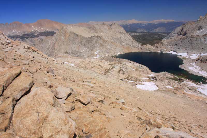
Tuesday August 30, 2011: Sawtooth Peak. Today was a very very tough slog of a day. This being my first experience in this region of the Sierra, I had no idea what I was in for. I set out for Little Five Lakes via Sawtooth Pass & Peak from the trailhead at 7:00 am. The trail was nice right up till lower Monarch Lake, then it was a sandy slog up to Sawtooth Pass. I was carrying a full pack with five days of rations, so the slog was really tiring to say the least. I made it to the pass and was rewarded with wonderful views east to the Kaweah's and the Whitney/Langley region. I dropped my full pack and traversed the sandy class two slopes to the summit with a bottle of water, my rain jacket, camera and a snack. The views from the summit were outstanding, Mt. Kaweah, Mt. Whitney, Mt. Langley, Needham, Eisen, Black & Red Kaweah were all on full display. I got back to the pass and pushed on. Originally I wanted to camp at Little Five Lakes but I was tired so I eyed the first of the Big Five Lakes to stay the night. The hike down through Lost Canyon was peaceful and before long I arrived at camp, made dinner and hit the sack, a very long and tough day.
 |
| Slogging Towards Sawtooth Pass |
 |
| Mt. Kaweah |
 |
| Columbine Lake |
 |
| Sawtooth Peak |
 |
| Myself On The Summit Of Sawtooth Peak |
 |
| Looking East Down Lost Canyon Towards Mt. Whitney & Mt. Langley |
 |
| Mt. Eisen & Black Rock Pass |
 |
| The Kaweahs |
 |
| On The Way Down To Columbine Lake & Lost Canyon |
 |
| Lost Canyon |
Wednesday August 31, 2011: Rest & Recover. Woke up with tired legs this morning. The 6,100' of elevation gain the prior day really took it out of me. I only had five miles to Little Five Lakes today where I would set up camp for the rest of the trip. I had my eye on Lippincott Mountain but wanted to keep my legs as fresh as possible for Mt. Kaweah which I would attempt tomorrow so I decided to hold off on Lippincott till another day. Instead I explored the lakes basins around Little Five Lakes. Lake 10,295' east of Lippincott and Lake 10,410' east of Mt. Eisen. Both lakes were easy cross country hikes from the Black Rock Pass trail and both were very scenic and peaceful. I scouted out the climbing routes up Lippincott and Eisen for a future trip and enjoyed the scene. I was able to relax, read and take photos, a good day indeed.
 |
| Morning Vista |
 |
| Black & Red Kaweah From Little Five Lakes |
 |
| The Big Arroyo |
 |
| Lippicott Mountain From Lake 10,295' |
 |
| Black Kaweah |
 |
| The Kaweahs From Lake 10,410's Basin |
Thursday September 1, 2011: Mt. Kaweah. Today was the day that would define this "peakbagging" adventure. Mt. Kaweah is a Sierra Club Emblem Peak. There are only fifteen Emblem Peaks in the Sierra's and Mt. Kaweah is one of them. I first saw Mt. Kaweah while climbing Mt. Whitney, the big red peak that dominates the western skyline and again from my High Sierra Trail backpacking trips. I had dreamt of this climb for a number of years and it was finally here.
I woke up feeling good, the easier going day yesterday allowed my legs to regain their mojo. The climb up Mt. Kaweah isn't technical, but it is physically demanding. It would take sixteen miles and five thousand five hundred feet of gain to reach its summit, no easy task. I set off at 7:00 am down the Black Rock Pass trail and three miles later made it to the High Sierra Trail junction. I would hike up the High Sierra Trail to the 10,600' tarn three miles up. I made good time and arrived at the cross country cutoff at 10:00 am. I now had 3,200' of cross country climbing to reach the summit. If I could climb 800' per hour, I would make the summit in four hours. I had researched the route and studied it thoroughly. I was able to make good time up the sandy/talus slopes. The views got better and better the higher I climbed. The Great Western Divide and Big Arroyo dominated the outstanding views. I reached the summit in two hours. The views east towards Mt. Whitney were spectacular, completely awe inspiring. I had a panoramic view of the Sierra's as far north as Mt. Ritter and Banner, The Palisades, Mt. Goddard, Mt. Williamson, Mt. Whitney, Mt. Langley, Olancha Peak, Rainbow Mountain, Sawtooth Peak, Lippincott, Eisen, Eagle Scout, Red Kaweah and Black Kaweah. Every direction had a grand mountain to be scene. I spent a good hour on the summit soaking up the scene. The weather was great as well, not a cloud in the sky, warm and calm. A very good day to be on a Sierra Peak. Going back down was alot of fun. I found a sandy scree slope and "Scree Surfed" all the way back to treeline, then traversed back to the High Sierra Trail. I felt really good all the way back to camp. Today was a good day in the Sierra's.
 |
| Morning Reflection |
 |
| Moraine Lake With a Fire Going On South |
 |
| Starting To Emerge From The Trees, Views Are Opening Up |
 |
| Sand And Large Boulders On The Ascent |
 |
| Great Western Divide |
 |
| Second Kaweah Comes Into View |
 |
| Having A Really Good Time :) |
 |
| Getting Close To The Summit |
 |
| First Views East From The Ridgeline |
 |
| Mt. Kaweah Is So Close |
 |
| The Red Spur, Mt. Whitney & Mt. Langley |
 |
| Looking Northeast From The Summit |
 |
| Benchmark |
 |
| Second Kaweah & Red Kaweah |
 |
| Looking North, Mt. Ritter, Mt. Goddard & The Palisades, Very Clear Views |
 |
| Black & White View Of Whitney & Langley |
 |
| Awe Inspiring |
 |
| Kaweah Lakes Basin |
 |
| Myself On The Summit, Today Was A Good Day |
Friday September 2, 2011: Eagle Scout Peak. After a good nights rest, I was up and at em for another peak. This time I set my sites on Eagle Scout Peak. I had wanted to climb this peak after seeing it tower over Hamilton and Precipice Lakes while backpacking the High Sierra Trail. I remember watching the glow of the sunset off the northwest face from my tent at Hamilton Lakes thinking, someday. Well, someday was today.
I headed down the Black Rock Pass trail to the High Sierra Trail again, but this time I made a left and headed north. The High Sierra Trail is a beautiful and grand Sierra masterpiece, one of my favorites. I would leave the trail at 10,300' and head west. The route looks imposing at first but it is easy to pick out a suitable route up slabs and grassy slopes. I had a good time climbing the class two route to the summit. I brought along my Five Ten Guide Tennies and the sticky rubber soles made climbing the slabs and talus a breeze. Once on the summit I was in photography heaven. The 360 degree views were out of this world. Precipice Lake was straight down 1500' below me, it looked as if you could jump directly into the lake from the summit. The Kaweah's looked grand as did the rest of the Great Western Divide, what a view. I made good time down the route and was back onto the High Sierra Trail and headed back to camp before long. Another great day in the Sierra's.
 |
| Morning Light |
 |
| I leave the High Sierra Trail here to begin the climb |
 |
| Looking To Nine Lakes Basin On The Way Up |
 |
| That Is The Goal Straight Ahead |
 |
| The Cool Looking Rock Formations Forming The Eastern Ridge |
 |
| The Saddle South Of The Peak |
 |
| Time To Turn Right, Don't Want To Climb That |
 |
| The Summit At Last |
 |
| Hamilton Lakes Basin With The Angel Wings And Alta Peak Behind |
 |
| Hamilton Lake And The High Sierra Trail |
 |
| Precipice Lake Straight Down |
 |
| Mt. Stewart & The Kaweah Gap |
 |
| Having A Good Time On The Summit |
 |
| Fabulous Views |
 |
| Black Kaweah |
Saturday September 3, 2011: Back To Mineral King. Today was the long hike back to Mineral King. I climbed up and over Black Rock Pass, then down the incredibly steep western side of the pass and down down down to the Timber Gap trail junction. I now know why people opt to climb the class three route up and over Glacier Pass instead of this route. By the time I reached my truck, I had hiked 14.7 miles and gained 3500' of elevation over rough trail. I made it to my truck at 2:00 pm and headed back down the Mineral King Road with a hot meal and shower on my mind. I drove to Bakersfield and got a room at the Econo Lodge. I was able to talk to my lovely wife and that set my mind at ease as it always does. This segment of the journey was complete but this was part one of a three part journey........
 |
| Heading Up To Black Rock Pass |
 |
| Empire Mountain |
 |
| Sawtooth Peak |
 |
| Pinto Lake And Cliff Creek Drainage |
 |
| Alta Peak On Ascent To Timber Gap |
Final Stats: 73.5 Miles, +21,800' of elevation gain.
Me and my buddies want to do a similar trip to yours. Can you help us with where we can find info on the region and any other helpful info.
ReplyDeleteMy email is berry77@sbcglobal.net
ReplyDelete