Sunday June 10th: Woke up at 0530 in the upper bunk of my Whitney Portal Hostel accommodations with three PCT roommates. I had climbed Mt. Russell and Mt. Carillon the day prior and before heading up into the mountains again, a nice place to sleep and shower was greatly needed. For only twenty dollars, it was just what I needed. I walked over to Subway for my breakfast, picked up my permit and called Judy one more time before heading up to the Cottonwood Pass trailhead. Lone Pine is at 3700' and the trailhead is at 10,000'. The drive up is accomplished via numerous road switchbacks that take you higher and higher until you are in the forest and cool mountain air. I had packed my backpack the night prior so I was able to get on the trail rather swiftly upon arrival. I had to do a few things like put the scented items in the bear lockers and secure my truck. I took my first step on the trail at 10:00 am.
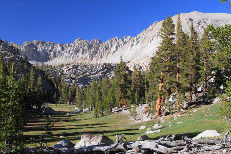
The Cottonwood Pass trail is a dusty and dry trail after a below average winter which we had this year. I trekked along humming a tune and before long was at the top of Cottonwood Pass, elevation 11,100'. The weather was great, not too hot, not too windy and clear. I now joined the Pacific Crest Trail for a few miles and encountered many folks heading to Canada from Mexico. Most start around April 15th and this was around 750 miles from the start. Only four more months and 1900 miles to go :o. The views were rather bland until I climbed above Chicken Spring Lake, then the views opened up. The Kaweahs and Great Western Divide to the west, Cirque Peak to the north and Big Whitney Meadow and Olancha Peak to the south. In a normal year there are small streams trickling down the slopes of Cirque Peak that you can get water from at normal intervals, not this year. I had to ration water for many miles until I met the creek coming down from the New Army Pass trail. After guzzling a couple of liters I hiked the final mile to my basecamp for this weeks peak bagging fun; the meadow below Soldier Lake. I would be all alone for the next few days, I had this magnificent spot all to myself. The views looking north included Mt. Langley, the meadow itself and the Corcoran/Le Conte group. I set up my camp, a very cozy camp and sent out a spot message to the wife letting her know all was well.
I was all done with camp chores around 4:30 pm and decided to go out and explore for a couple of hours. Tomorrow's destination was the Mitre Basin and a couple of peaks so I set out to Lower Soldier Lake and climbed the west slope leading to a small summit above the lake and the basin. The views looking up canyon were great, well worth the effort. So many grand peaks to explore, hopefully I get to them all someday. I enjoyed a snack and took some photos and plotted a course with my map and compass. Tomorrow was going to be an adventure......
 |
| Big Whitney Meadow |
 |
| Mt. Ana Mills & Mt. Kaweah |
 |
| The Mitre Basin |
 |
| Mitre Basin & Tree Snag |
Monday June 11th: Woke up at 0700 feeling pretty good. The night was chilly, but I was comfortable. I made my Oatmeal and Peanut Butter breakfast, had some coffee and headed out to the Mitre Basin. As chilly as it was during the night, as soon as the sun came over the western ridge, it warmed up nicely. The weather was on my side today. I went back to Lower Soldier Lake to start my climb into the Mitre Basin. I got my first look of the day at the basin once I crested the saddle above Soldier Lake. The early morning light was breathtaking on the high peaks forming the eastern boundary of the basin. The plan I formulated was to climb to Sky Blue Lake, climb higher to the north western lakes below Mt. Pickering, climb the northeastern slopes of Pickering, traverse to Joe Devel Peak and descend back to the Rock Creek Trail and back to camp, simple enough :o. Looking at the steep eastern escarpment of Joe Devel was awesome, very rugged looking.
The Mitre Basin is a glacier carved valley with Rock Creek flowing down the middle of it. There are many lakes feeding Rock Creek and the crown jewel (or the most known) is Sky Blue Lake. I ascended to base of the cliffs that damn up Sky Blue Lake at 10:00 am. It was a great scene. Deer prancing about in the meadows, Mt. Langley, Mt. Corcoran, Mt. LeConte and The Mitre standing guard to the east, Mt. McAdie to the north and the steep slopes heading to Mt. Pickering to the east. I wish I had more time to just chillax in this area, definitely coming back :) Sky Blue Lake itself is beautiful, I took a nice fifteen minute break here to soak up the scene. There were eight inch plus Golden Trout swimming about the shore, good times.
From Sky Blue Lake my path was to the west/northwest to the lakes below the slopes to Mt. Pickering. It was getting more and more talus like, the footing and speed not what they were lower down in the basin. Mt. Pickering was my objective now. I had a 1,000' talus slope to climb to get to the saddle between Pickering and its un-named peaklet to the east. The first couple hundred feet were snow bound. I didn't bring any snow/ice gear so I had to test the snow. If the snow was soft enough, I could kick a boot track and travel safely, if it was ice, I would have to find another way. I picked up a shot put sized rock and lobbed it at the snow. It landed and sunk in a few inches, a great sign. If it had bounced and slid off, not good times. I proceeded with caution up the lower snow slopes, the snow was easy to travel on, not too hard and not too soft. I made it to the beginning of the talus hop in ten minutes and started up the talus. The snow covers up the talus and makes traveling easy, but now that I was on talus, careful foot placement and navigating the loose rocks were vitally important. Any given rock could be sturdy or move when I placed weight on it. It can be tedious and sometimes stressful climbing up a talus field. This particular climb wasn't too bad, I made careful progress trying to find boulders that appeared sturdy and anchored. I made the saddle in good time and stared up at Mt. Pickering another 500' above me to the east. Now the rocks were very large, but much sturdier. Careful foot placement and balance are still important, but this type of climbing is much preferred to the loose stuff down below. It didn't take long until I was on the summit of Mt. Pickering, elevation 13,485'. The views were outstanding. Mt. Whitney dominated the skyline to the north, Mt. Langley to the east and the Kaweah's to the west. Of great interest was the ridge line connecting Pickering to Joe Devel, sure looked jagged and loose. I had my victory snack on the summit and sent out my SPOT message. Apparently I had cell service way out on this remote peak as text messages started to come in? I decided to call my wife and see if it would go through and low and behold I had a quick conversation with her from the summit of Mt. Pickering. (I had a good laugh about this later, I can barely make a clear phone call from the living room of my house but made a crystal clear call in the middle of the High Sierra, gotta love technology).
After soaking in the views and enjoying the mighty peak it was time to turn my attention to Joe Devel. I would have to drop down to just under 13,000' and climb back up to 13,325'. The climb down the ridge off Pickering was straightforward, just large sturdy talus hopping. The views down into the lake basin holding Erin Lake looked sandy and inviting, but I wasn't going there. I was heading for the serrated ridge line connecting the two peaks. I zig zagged my way down the boulders staying to the east of the ridge until the low point. There I climbed up to the top of the ridge to have a look at where I would go next. To my chagrin it was a steep cliff. I went back to the east side of the ridge and continued on until past the next gendarme (large rock formation) that was blocking the ridge. I climbed up onto this ledge to get a look and saw where I should be going. Problem was, that area was blocked by a steep snowfield. Hmmmm, what to do. I was rather committed at this point, if it became too unsafe I could descend into the Perrin Creek drainage or back down to Erin Lake, but I would prefer to figure out a route to the summit and head down the sandy south slopes of Joe Devel. I sat, actually stood awhile looking at different rock options. Most of them looked loose and dangerous. The best route was just on the other side of the snowfield, but to get to it safely, I would have to descend a hundred feet or so down a loose looking chute. I carefully proceeded down the chute, the rock was indeed loose and sandy. I pretty much slid down on my butt, a couple of instances I found myself in a slow rock slide that would sluff up and stop, almost like a snow slope. I finally found an exit slope going up that would take me to the far side of the snow field. This turned out to be a loose slope as well. One move upwards brought a bunch of loose rock down upon my legs scratching me up a bit. Another step dislodged a microwave sized boulder that I got a thrill of watching crash down and down the chute I had just climbed up. I finally made it to ground that I could stand upright on, and it was a relief. That section of traverse, descend, ascend was stressful and not very fun. But now the pay off was smooth sailing to my second 13,000' peak of the day, Joe Devel Peak, elevation 13,325'. The final approach to the summit was easy going sandy slopes, not the kind of sand that you slide around in either, nice firm sand. The views from the summit were great, Whitney, Langley and Kaweah dominated the views again and there is nothing wrong with that. I sent out my SPOT message, had another snack and headed down the sandy slopes towards the Rock Creek Trail. Very enjoyable for the first 2000' of descent, but once entered the forest I had to descend a pretty steep cliff to get back to the trail. Once on the trail it was easy going back to camp. Overall an adventurous and memorable day.
 |
| Rock Creek |
 |
| Sky Blue Lake |
 |
| Upper Tarn Below Pickering's North Slope |
 |
| Heading For The Pickering Saddle |
 |
| Mt. Whitney, Mt. McAdie |
 |
| Mt. Langley |
 |
| Mt. Whitney |
 |
| Myself On The Summit Of Mt. Pickering 13,485' |
 |
| Mt. Langley On The Descent To Joe Devel Saddle |
 |
| The Pickering/Joe Devel Traverse |
 |
| Sandy Slopes Of Joe Devel |
 |
| My Days Track |
Tuesday June 12th: Slept great last night, my sore quads needed the rest. Today was supposed to be a relax day, but I still wanted to get in a peak, so what to do. I looked over the map and decided on Mt. Guyot. I had climbed it in the past and relished the outstanding expanse of peaks you see from the summit and headed off to tag it again. Yesterday was cross country almost the entire day, today would be mostly on trail sans the 1400' ridge climb of Guyot. I would be hiking along the PCT for most of the day and hearing the tales they offered would be interesting. I headed off down the Rock Creek Trail at 0800 and made good time on the downhill section, all the way to the Rock Creek Campground just beyond the ranger station. While taking a break I got the idea to hike up into Forgotten Canyon and possibly roam up to Mt. Anna Mills, it is the opposite mountain across from Mt. Guyot guarding Rock Creek. I started off on the south bank of Rock Creek and started angling southwest to intersect the canyon. After thirty some odd minutes of cross country travel and I had second thoughts, today was supposed to be a chill day, lets go back to the trail and climb Guyot. In hindsight, this ended up being more work, but at the time it seemed reasonable.
I made good time going from Rock Creek, elevation 9600' to Guyot Pass at 10,900'. Now it was time to climb the ridge to the summit. It is a 1400' ridge climb with good rock, a very pleasant climb compared to the loose stuff commonly encountered. The star of the show is the wide ranging views from Guyot. The mountain is west of the Sierra Crest and east of the Kaweah's, pretty much an unobstructed view in all directions. I reached the summit one hour from leaving the pass. I signed the register, sent a SPOT message, had a snack then got out the map and compass to name all the peaks I could see. I got up to 40 named peaks easily viewable from the summit. Being a photographer, I was in a good place. The climb was worth it.
I made my way back down the ridge and huffed it back to camp on established trail. I made it back to my camp at 5:00 pm, hastily made my dinner and hit the sack. I was going to wake up early tomorrow morning to tag Mt. Langley and get back home.
 |
| Rock Creek |
 |
| Red Spur & The Kaweah's |
 |
| Climbing The Ridge To Mt. Guyot |
 |
| The Kings-Kern Divide |
 |
| Mt. Whitney |
 |
| View From My Camp |
 |
| Todays Trek |
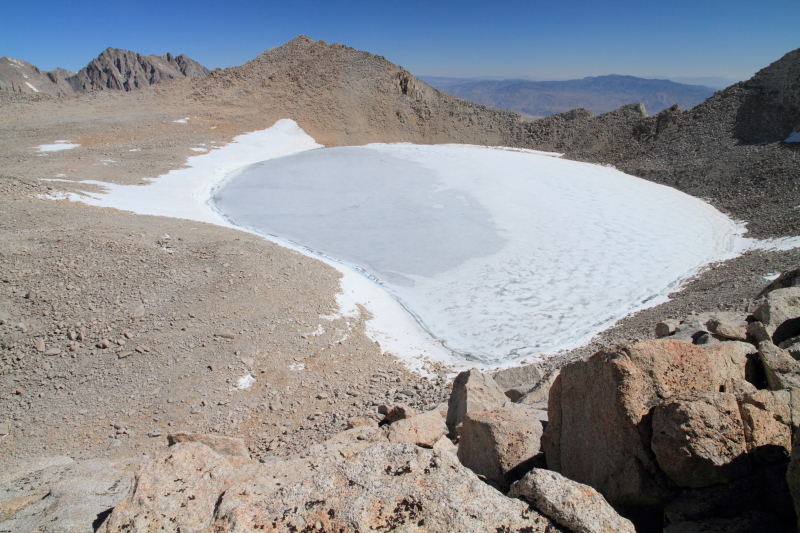
Wednesday June 13th: Alarm going off at 0300, what in the world, oh yeah, this is what I wanted. I made my breakfast and packed up my camp by headlamp and was able to get on the trail at 0345. Felt pretty good as I climbed through the dark up towards New Army Pass. I got up to Army Pass/New Army Pass junction just as day was breaking. I dropped off my pack and headed to Mt. Langley with a camera, snacks and water. The sandy slopes of Langley can be a pain but today they went by quickly. The views were great looking west to most of my week's climbs. Joe Devel, Mt. Pickering, The Mitre Basin, Soldier Lakes, Rock Creek and beyond. The best views though are at the summit plateau looking north towards Whitney, what a scene. I arrived on the summit and took in the wide encompassing views. This region of the Sierra Nevada is tall and rugged.
I took my photos, signed in on the register and began my descent to my truck. The sand slopes are a slog going up, but a breeze going down. I made it back to my pack rather quickly. I walked out to the top of Army Pass to have a look. There was one troublesome snow field right at the top that blocked progress. I did my rock toss test and the rock bounced off the apparent ice, not going that way. So, I proceeded up the south facing New Army Pass. It is pretty, but it is much longer that the Army Pass route, but today that would have to be okay because it was safer. I trudged along the sandy trail for what seemed like forever back to my truck, but I made it at 12:30 pm. Good Day in the mountains.
I drove back to Lone Pine and took a nice, hot, refreshing shower at the Hostel, boy did that feel good. I grabbed a sandwich from Subway and motored on back home. Overall a great six days in the mountains. All told I did 71.4 Miles and gained 21,100' of elevation while climbing Six Sierra Nevada Peaks ranging from 12,300' to 14,086'.
 |
| Joe Devel Peak |
 |
| Morning Light On Joe Devel & The Kaweah's |
 |
| Mt. Whitney From The Summit Plateau |
 |
| Myself On The Summit |
 |
| Sky Blue Lake |
 |
| Mt. Whitney |
 |
| Polemonium aka Sky Pilots, My Favorite Flower |
 |
| Today's Trek |