Sunday, April 29, 2012

Mt. Whitney via Snowy Main Trail


April 28, 2012: Work schedule and weather finally aligned for a spring climb in the Sierra Nevada and why not go for the highest peak; Mt. Whitney. 

I left Simi Valley for Lone Pine at 0730. Perfect drive, no issues and good views, well past Mojave there are good views. Arrived at the visitors center to pick up my non quota permit at 11:00 am and headed up to Whitney Portal. The view of the Sierra Crest from Whitney Portal Road is grand. Mt. Whitney, Mt. Langley, Lone Pine Peak (gets mistaken for Whitney by a lot of 395 motorists) and Mt. Williamson to name a few. I set up a quick camp at the backpackers campground and explored the Portal. There was a powerful wind storm that affected all of the Sierra Nevada on November 30, 2011 and this area was hit hard. A large tree fell right onto the site I used last Labor Day at the campground. Gave me the chills.  The crews have done a remarkable job of cutting and clearing the downed trees. While I was there, Doug Sr. (who owns and runs the Whitney Portal Store and Hostel) was pulling downed trees out of the trout pond with a truck. 

I decided to do a warm up/exploratory hike up the North Fork of Lone Pine Creek. I had been up it before, but it was pitch black and by headlamp, I wanted to see it during the daylight hours. I am attempting Mt. Russell as an overnight trip in June so this was an exploratory trip as well. Got started on the trail at 1330 and made good time to the Mountaineers Route cutoff. From there it is a steep uphill on the north side of the creek. Soon I crossed to the south of the creek then back across to the south. Progress up the canyon is blocked by thick willows and brush. To keep going one must climb the class three Ebersbacher Ledges. Being on the route before really did help. Though it was dark, I remembered the moves and route. Once past the ledges it is a easy walk up to Lower Boy Scout Lake. The views in all directions were great. I was last here Memorial Day weekend and what a difference. The snow is significantly less. The route to the upper lake is mostly rock now. I took some mental notes for my Mt. Russell climb and headed back to the Portal. I got there in time for a delicious burger and fries then hit the sack at 1930. 

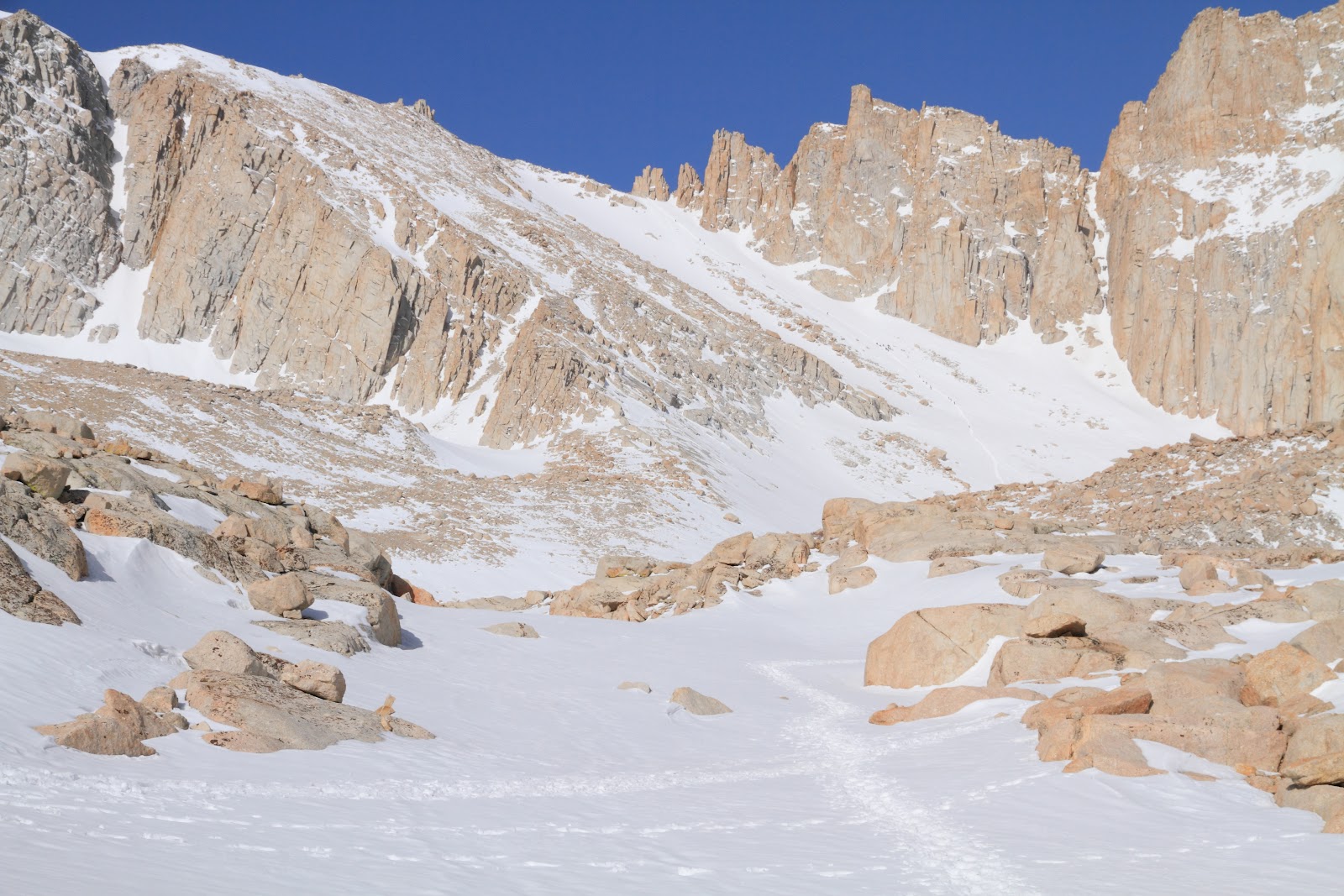
After a restless tossing and turning night of mediocre sleep I was awake at 0330. Packed up camp, made breakfast and had last minute prep and checks. I was on the trail at 0430. I didn't see any other day hikers for some time, for the most part I was on my own for the first few hours. Perhaps the overnighters were on to something. The 2012 winter season is the sixth worst since records were kept according to the CDEC and evidence of that is all around. I didn't have to put on any snow gear until 11,000'. (Just last year the trail wasn't snow free until early July.) I strapped on the crampons and headed up towards Trail Camp. I felt good despite the restless night of rest and little acclamation. Once at Trail Camp I found out where all the people were hanging out. Trail Camp was a zoo, it looked like a mid July crowd. I could see the conga line of people heading up the slope to Trail Crest. Well, I had an objective, catch and pass as many as possible (this genius plan of mine would cost me later). I made good time up the 1700' slope, the line of people kicked in a nice boot path that was easy to follow. I made it from trail camp to trail crest in 1:30 and I was able to pass nine people. Good times so far. The view west from Trail Crest is one of the best there is, I am always impressed, it will never get old. I took off the crampons and walked across the soft snow to the JMT junction. I took a small break and had a snack. At this point I realized how little water I had consumed to this point. I continued up to the base of Mt. Muir and took another break. Why was I having to slow and stop so much? I continued on to the 14,000' level and abruptly stopped. I was feeling terrible. Headache, fatigue, thirsty. Wow, I was suffering the effects of Altitude Sickness. I took a longer break and tried to figure out how this was happening to me. Well, it had been seven months since I was at this altitude, I was not well rested, dehydrated and did not pace myself very well. I drank what was left of my water and tried to refill with snow, but that was not working out very well. From here to the summit I took it really slow. I would count out one hundred steps and rest. The headache was zapping my strength, Excedrin wasn't helping at all. I told myself I could continue as long as dizziness, nausea or light headed occurred or started. After what seemed like forever I arrived at the summit at 1245. I contacted my wife via the Spot Connect to tell her I was on the summit and safe. I took some photos and ate some lunch. Here was another mistake. I only brought candy bars and junk food. Snickers, Pop Tarts, left over Easter candy. Though tasty, it wasn't supplying lasting nourishment to fuel this grueling climb. Simple carbs weren't enough. The views were enough to make this seventeenth summit worth the effort. All those mountains to climb and Whitney looking over them all. To the north were a couple of fourteeners I am to climb this summer, Mt. Russell and Mt. Williamson.....hopefully.

After a half hour to rest and recuperate I headed for the long journey back to the Portal. As soon as I started the headache made itself known again. It would accompany me the entire way down unfortunately. I made my way back to Trail Crest in a very methodical pace, the headache was terrible and I was still low on water. What a pain in the arse. At Trail Camp I had a decision to make. Plunge step down the 1700' slope back to Trail Camp or Glissade. This slope has been the end of a few hikers time on this earth because of out of control glissading in un ideal conditions. The slope was in great shape going up and appeared to be so now. This slope loses the sunlight very early in the day and can turn into an ice rink in no time. I have successfully glissaded the slope in the past and after careful consideration decided to give it a go. Out came the ice axe and water proof clothing and off I went. The snow was actually too soft for a swift glissade but I managed good time down the slope. If I ever needed to slow down I just leaned back and let the snow sluff build up and stop me without the axe. Very safe condition. At Trail Camp I took a nice long break, got some water and another snack. Headache was still with me, I was hoping it would subside with the elevation loss, but it did not. From there it was retrace my steps back to dry trail at Mirror Lake. Problem was, the snow was softening up and postholing was a problem. After avoiding the land mines I made it back to nice dry trail and it was supposed to be smooth sailing to the truck, but......

A grouse is a chicken looking bird that loves to stalk and attack me on mountain trails. I had a run in with one on the Meysan Lake trail a couple of years ago. That one tried to scratch out my eyes and end me. I narrowly evaded doom. Back to now. I was at the 9300' level on the trail when I heard the eery call of the Grouse. It is a deep moan that echos throughout the forest. Right in front of me were two females. Grouse are fearless and are not impressed with humans. I clacked my poles together in hopes of scaring them away, that tactic works on Bears and Coyotes, but not Grouse. They are crazy, angry chickens. These two females were attacking each other and not me for the time being. I would normally try and give them a wide berth but I was in a section of trail with a drop off on the right and thick brush to the left, nowhere to go. They continued to fight each other right in the middle of the trail. I tried throwing rocks in their direction. That did nothing to them, they just looked over and made a terrible groaning noise. I decided to put on my sunglasses, got out my ice axe and ran right through them. I was worried they would take flight and scratch out my eyes. I know this must sound funny but I was truly scared of these terrible critters. Somehow I made it through the gauntlet to the other side. A normal wild bird would be terrified of a six foot human running at them with an ice axe, not these two, they didn't even budge as I ran by. That whole event took about ten minutes, mostly me trying to get them to move. I quickly moved away from the drama and quickly ran into the bid bad male Grouse. This thing had his feathers all ruffled up, his tail feathers looked like a Turkey and his neck feathers were brilliant yellow and orange and he was pissed. He made an even more disturbing sound. WTF. I wanted nothing to do with this crazy bastard so I cut some switchbacks hoping to get away from them but ran into two more. I went off trail some more to evade capture and certain death by crazy chicken. I must have come across a nesting site. Next time I will be better prepared, time to make friends with an El Pollo Loco chef who hikes. I made it back to my truck at 1830, cleaned up and headed for Subway. After dinner I drove all the way back to Simi Valley. I felt good after dinner and made it back safely. What a weekend. 


This trip was an eye opener for me. I made a lot of small mistakes that added up to cause my feelings of not so well being. I made a list below. I consider myself experienced but humble. Mt. Whitney taught me a valuable lesson today. Not only do you have to prepare and train for snow travel, self arrests, proper crampon use, emergency shelters, first aid, the list goes on and on, but you also have to take care of the smaller things such as diet, hydration, rest, pace. 

Mistakes/Issues: 
Restless Sleep At Altitude: Not much can be done about that, just need to be at elevation longer, can't always afford that luxury. 
Poor Trail Diet: (Candy Bars=Simple Unsustainable Carbs, No Complex Carbs). Need to balance out the candy with some sustainable energy sources. Peanut Butter, Pretzels, Honey, Nuts, Dried Fruit. 
Waiting For Warm/Burn Feeling To Put On Sunscreen: I admit it, I do not like sunscreen. Goes back to my fishing days, don't like the slimy goey feeling. But it is a necessity up high. I usually wait too long to apply it. I need to apply it much earlier in the day. 
Going Fast Up Trail Crest Slope: I made the critical mistake of racing up the slope to pass people. Instead of taking my time and resting along the way, I stormed up the most taxing section of the entire trail. 
Not Enough Pack Off Rest Breaks: There are two kinds of breaks, quick pack on breaks and pack off breaks. I needed to take more pack off breaks to not only rest, but to acclimate to the altitude. 
Not Enough Water, Waited Too Long To Hydrate, Damage Was Done: By the time I really needed the water, there wasnt a water source. I needed to fill up at Trail Camp. Needed to take the time to hydrate which I did not. 
Not a fan of the Grouse aka Angry Fearless Chicken :/

Here are some photos. All can be viewed here:  http://calicokat.smugmug.com/Hiking/Sierra-Nevada/Mt-Whitney-April-2012/22697072_KtBmL7#!i=1819651925&k=zjn9fxv
First Morning Light

Alpine Glow

Looking Towards Trail Camp

Having Fun So Far

Following The Boot Track

Slope To Trail Crest

Looking Down From Slope

At Trail Crest

View West 

Mt. Brewer

View From The Windows

Mt. Hitchcock

View North 

Myself, Headache And All On Whitney For The 17th Time

Mt. Tyndall & Mt. Williamson

Mt. Randy Morgenson

Frozen Tarn Melting 

View East On Way Down 

Topo Map


Monday, April 2, 2012

Mt. San Gorgonio via Northeast Ridge

March 30, 2012: Alarm clock went off at 0330, too early, but it was necessary if I wanted to make it out to Gorgonio. I had pre planned and all my gear was already packed. Makes it alot easier to get out the door when all I have to do is get coffee and breakfast. I hit the road for the long drive out to Redlands at 0400. Thanks to Sirius Satellite Radio I was able to listen to Howard Stern, Mike & Mike on ESPN and later Mark & Brian to pass the time. I made it to the trailhead, packed everything up and started off at 0700.
 
Not knowing what the conditions were, I brought snowshoes, crampons, ice axe and micro spikes. Ready for anything I suppose. There wasn't much snow on the trail until the 8000' mark. From there it was consistent coverage. Not icy though, so I kept on moving in just my boots. I arrived at the "winter route" cutoff above South Fork Meadows and tried to continue on with just boots but I started to sink in to my knees so I put on the snowshoes. Travel was once again a breeze and I made good time up the moraine fields to the clearing below the northeast ridge at 9,500'. The snow was still punchy enough to allow the snowshoes to stay on. Up until now, there wasn't a previous track, I was breaking fresh trail. Once I rounded the ridge and started to head up the chute I found all the evidence of past treks up. A line of tracks coming and going at the 10,000' mark. I looked around and did not see any tracks heading to the top of the ridge so I decided to head up to the top of the ridge to have a look. The route I took was steep but pleasant and before too long I was standing on the ridge looking down the other side at the "Big Draw". There was great coverage in the draw and took some mental notes for a future trip. There were great views all the way out as far as Mt. Baldy. The conditions changed soon thereafter, the terrain was too steep for snowshoes (a slip would lead to much worse with snowshoes on), but the snow was too soft for crampons. I took off the deathtraps/snowshoes and went at it in just my boots. I would have to kick into the snow with some force to create a step that would hold my weight. This was going to be tiresome, I still had a 1000' to go on the ridge. I made slow progress this way and was losing energy quickly. I decided to try my luck on top of the very ridge where there was less snow and more exposed albeit loose rock.
 
Travel on the ridge was tiresome as well, the loose rock interlaced with snow made for difficult moving conditions. At 11,000' I ran into ice covered scree. Slippery on top, then loose an inch below. This was not only tiresome, but becoming dangerous. Crampons would dig right through the ice but gain no purchase in the loose scree. Being on a steep angle meant slipping and sliding no matter what I strapped on my feet. Did not want to slip on the scree then pick up speed and momentum on the layer of ice. The top of the ridge was only 200' above me, but it seemed miles away. I decided to take off my pack and have a seat bracing against a weathered tree on the ridge, at least the views were great. After pondering my options I opted to loose some valuable elevation and head back to the ultra tiring snow kick stepping I had done earlier. This plan did work out and I topped out on the ridge (11,200') at noon. I was tired though, I could feel the lactic acid build up in my quads and was grateful that the climbing was just about over. Not sure I could have continued on like that for very much longer. I traveled with ease across the ridge and made the summit of San Gorgonio (11,502') at 12:45.
 
I was very tired and fatigued at this point, I had dipped too far into my energy reserves and hadn't consumed enough food or drank enough water. I quickly made a peanut butter and honey sandwich and crammed some cheese-its down. The funny thing is I was not hungry, food wasn't appealing. I had to chuckle to myself, the thing my body needs most is the thing my body does not want. I felt instantly better after the power lunch and refocused my energies on getting back down. I wanted to try and glissade down the chute east of the ridge and dressed appropriately; rain jacket and pants. I walked back down the summit ridge and picked a line down the chute that seemed good. I could see a band of rocks exposed a third of the way down and made a mental note, a strong mental note. With ice axe in hand I did a sitting glissade. I wasn't expecting to get very far based on the snow conditions over on the ridge, but I was able to glissade from 11,200' to 10'000'. It was alot of fun to say the least. I changed my gear out and put the snowshoes back on for the descent to South Fork Meadows. I did not follow my path back out, instead I ventured over to the chute going down next to Charlton Peak. It was enjoyable wandering around the moraine fields, there wasn't any real purpose for this, just felt like wandering.
 
I made my way back to my truck and arrived safely at 4:30. Another great outing in the mountains.........
 
The Big Draw

Northeast Ridge To The Right, Descent Chute To The Left

Jepson Peak

Jepson Peak From Atop The Ridge

Mix of Rock, Snow & Ice

Mt. Baldy Out In The Distance

On The Summit, Tired But Happy

Glissade Path

Grander View Of Glissade Path (1200'

Topo Profile Of Route
 

Friday, March 23, 2012

Mt. Baldy & West Baldy

March 21, 2012: To celebrate the first day of spring I took a trip up to Mt. Baldy. I climbed this peak back in January with no snow. As luck would have it, the local mountains received three to four feet of the white stuff the weekend prior. This would be the first snow hike of the season up Mt. Baldy.

I got a rather late start up the Manker Flat trailhead at 0800. I was being cautious about black ice on the road so starting a tad later was indeed helpful. I started off in one layer and that would be all I needed until the summit ridge. It was a rather balmy fifty degrees when I started. Luckily, the snow was firm and travel was easy. I wore microspikes all the way to 9200'. At this point the postholing began in earnest. I had lugged my snowshoes all the way up and that was about to pay off. I made it enjoyably to the summit of Baldy around noon. The warm day was halted by a brisk thirty plus mile per hour wind. It made the summit an uncomfortable place to eat lunch.

I retreated off the summit and headed towards West Baldy a half mile away. The winds diminished on the ridge between the two peaks and I was able to have some lunch behind a tree. The walk over to West Baldy was nice and easy. The photos of wind sculpted snow and ice were great, made the walk over worthwhile. From West Baldy, I made a direct line to the top of the Baldy Bowl and followed that ridge back to the Ski Hut and down to my truck. It was a great day in the mountains.

Baldy Bowl

Looking Down Towards Upland

Plane Crash Debris

Summit Of Baldy

Snowy Southern Sierra's

West Baldy From Mt. Baldy

Close Up View Of West Baldy

Mt. Baden Powell

Wind Sculptures

Staying Warm In The Fierce Wind

Mt. Baldy From West Baldy

Top Of Western Bowl Chutes

Baldy Bowl

Sunday, March 18, 2012

Hines Peak & The Topa Topa Bluffs

March 16, 2012: Hines Peak & The Topa Topa Bluffs, 22.4 Miles, +6200' of elevation gain. The plan was to get up to the Sierra's to some snowshoeing, but there was a potent winter storm that ended up dropping three to five feet of snow in the upper elevations. That same storm would drop a couple of feet on the local mountains as well. So, my window was to get a local hike in on Friday in advance of the storm. I wanted to get some miles and elevation gain in, so off to the Sespe Wilderness I went.
 
The trailhead is only forty five minutes from my house opposed to the two hour drive to the Gorgonio wilderness, so this really felt local. Hines Peak is 6,716' and my trailhead today is at 1,750'. I started at 8:30 am in a cool overcast canyon. Nothing to see for the first five miles but fog. The fog lifted at 4,500' and the views were pleasant. I have done this hike before so nothing out of the ordinary was expected or encountered. I made it to the summit of Hines Peak in four hours and enjoyed some Pop Tarts for lunch. The valleys below were shrouded in fog still. The views of the Topa Topa ridge to the east were impressive as was the view north to the Sespe River drainage.
 
I backtracked from the summit of Hines Peak and made my way back to the Topa Topa Bluffs. It is an easy walk up with great views of the swirling fog. Normally you get a grand view of the Ventura County plains and the Channel Islands, but not today, the fog wasn't having it. I made my way back to my truck and arrived at 4:30 for a nice eight hour jaunt in the Sespe Wilderness.
 
GPX Track

Hines Peak Summit Ridge

Looking East From Hines Peak Summit

Hines Peak From Below Topa Topa Bluffs
 

Monday, March 5, 2012

Dewey Point, Yosemite Valley & The Mariposa Grove

Judy and I had been planning a Yosemite winter trip for a long time and finally we were able to take it..........

Friday March 2nd: We packed up our belongings and hit the road to Oakhurst in the late morning. The drive up was great, little to no traffic and lots of road snacks (candy, yogurt, sunflower seeds, soda's, fruit, Sushi :o ). We made a pit stop at the Fresno REI to pick up an insulated mug for our snowshoeing coffee :). We checked into the Days Inn Oakhurst, then had a nice dinner at the Crab Cakes restaurant in town. Lobster, Calimari Steak and Carrot Cake. Good travel day, time to get rested up for tomorrow........

Saturday March 3rd: After a good nights rest, we were up and at em at 0600. We didn't leave the room until 0730 though, it was cold outside which slowed our progress. An overnight low of 28 degrees iced up everything outside and warming the truck up took a few minutes. The plan was to grab some breakfast at Subway then head up to Badger Pass inside Yosemite National Park. Problem was, Subway forgot to open on time, so plan B was Carls Jr. chicken sandwiches. Yosemite had received a foot and a half of new snow the past few days and chain restrictions were in place from Highway 41 to Badger Pass. We had the chains with us and even practiced putting them on before leaving. Once on the road, we found chains were not needed. We carefully worked our way to the Ski resort and arrived safe and sound at 0845.

We took out our backpacks and packed up all the essential winter gear, but the weather was turning very late spring like, warm and pleasant. The weather would turn out to be great the next two days. We strapped on our snowshoes and headed down the recently groomed Glacier Point Rd. to the Dewey Point Meadows turn off. We took our time the first mile. Judy had never been on snowshoes before so getting the timing and wider stance took some practice, but she got it down quick. She actually enjoyed the softer off trail snow to the groomed packed snow. There was a nice path through the snow, no navigation required today. We made good time through the meadows in good snow conditions. About two to three feet of nicely packed down powder.


Start Of The Snowshoe

Having Fun

Beautiful Conditions

We made it to Dewey Point at high noon and what a view. A visual treat. The vista's in all directions were outstanding. Particularly to the north and east. El Capitan, Yosemite Valley, Ribbon Falls, North Dome, Tenaya Canyon, Clouds Rest, The Top Of Half Dome, Sentinel Dome, Cathedral Peak, Unicorn Peak, Mt. Clark and the Clark Range. What a site. We ate our snacks and enjoyed our hot coffee. The REI mug really worked, five hours after pouring the coffee, we were sitting at the edge of a cliff enjoying a hot cup of joe. Good times indeed. After taking our Yosemite Portrait Photographs, we made our way back the way we came. We both had a great time. Judy was feeling so good she decided to fall/leap into the snow for fun :) We made it back to Badger Pass in time to have a chicken sandwich and some fries.


El Capitan From Dewey Point

Judy and I w/ Half Dome & Clouds Rest Behind

Half Dome & Clouds Rest

Cold Leap Of Faith

The next stage of our journey took us down to Yosemite Valley for some late afternoon and sunset photographs. We stopped off at Tunnel View, Bridalveil Falls, Yosemite Falls, The General Store and the meadow next to Curry Village for Half Dome sunset photos. The weather was great and there were hardly any people in the valley. We were very pleasantly surprised, felt like we had the park to ourselves...well, mostly :)


Tunnel View

Zoomed In Tunnel View

Bridalveil Fall w/ Rainbow

Bridalveil Falls Straight On View

Bridalveil Falls Again :)

Half Dome

North Dome

Black & White Half Dome

Sunset Glow

After photographing and witnessing a beautiful sunset, we made the long drive back to Oakhurst. The drive actually went by fast, good company. We had ourselves a nice Turkey dinner, ate some Ice Cream and hit the sack. We would sleep well tonight. Today was a good day :)

Sunday March 4th: After a great night of rest we were ready to enjoy some more scenery and hiking in Yosemite. We packed up our belongings, checked out of our room and actually got breakfast at Subway. Apparently they open around seven, not at seven which is why we missed then yesterday. Today's plan was to head up to the Mariposa Grove just inside the park boundary. We have been to the Giant Sequoia groves of Sequoia National Park, but not to any of Yosemite's. We got to a mostly empty parking lot at 0930. Ah, got to love the winter, this same scene in the summer would be overwhelmingly crowded.

We set off to see "The Grizzly Giant", "Tunnel Tree" and the Upper Grove. The Sequoia's are a thing of might and beauty. Photos don't do justice to how majestic they truly are; The largest trees in the world. The Grizzly Giant is the fifth largest tree in the world. It was icy and a little snowy at the beginning of the trail, Judy wore micro spikes and I used poles for stability. It took us a few hours to hike a loop through the lower and upper groves, stopping to take photos and admire the scene all around us. In total we hiked 5.8 miles. When we arrived back at my truck, the parking lot looked alot like the summer, cars and people everywhere. The warm day brought the people up to the park in droves. We cleaned up and headed home at 1:00 pm. We made good time coming home, just missing a big rig turned over in Valencia and made it back at 6:00 pm. Overall a great weekend in the Sierra's. I really believe Judy will snowshoe with me again in the future, she liked it that much :) Gracias Mi Amor......

Giant Sequoia

View From Below

Myself

Judy